Get ready to strap on your hiking boots and journey into the heart of Arizona’s undiscovered trails. The article, “Beyond The Grand Canyon: Arizona’s Lesser-Known Hiking Treasures” unveils hidden gems off the beaten path that are just as stunning, yet not as crowded as the illustrious Grand Canyon. Take a visual trek through towering red rock formations, serene desert landscapes, and verdant creekside paths that Arizona holds, waiting for explorers like you to come and unearth their beauty. So, pack up your gear and let’s venture together into these lesser-known hiking treasures.
Havasu Falls
Location
Havasu Falls is one of Arizona’s most breathtaking natural gems. Nestled in the Havasupai Indian Reservation, it’s tucked away from the main tourist attractions, located near the tiny village of Supai. The distinct blue-green water against the striking red rocks is a view you’ll relish.
Accessibility and Trail Conditions
To get to Havasu Falls, prepare yourself for a long hike. It’s around a 10-mile trip, one way. The trail can be rough and rugged, making it a journey best-suited for seasoned hikers. It can get especially taxing during the hot summer months, so ensure you’re well-hydrated and sun-protected.
Unique Features
Havasu Falls’ most unique feature is unquestionably the colour of the water. Thanks to high concentrations of calcium carbonate and magnesium, the falls has this impressive turquoise color that looks almost dreamlike against the contrast of the red canyon.
Things to keep in mind
Take note that the Havasupai tribe manages this area, and you need a permit before hiking to the falls. Remember to respect their land, keeping it as pristine as you found it.
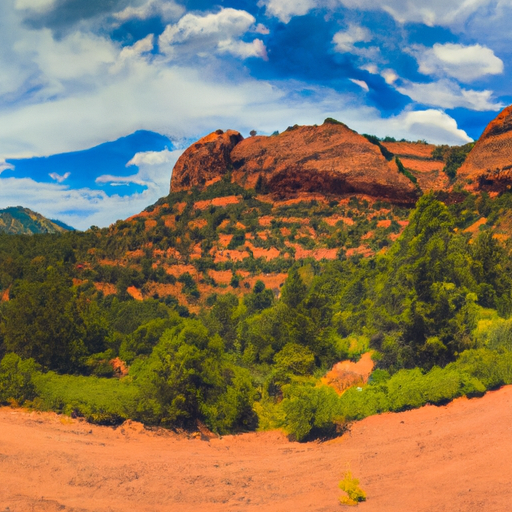
Red Rock State Park
Location
Next stop on our list is Red Rock State Park, situated near Sedona, famous for its striking views and lush green vegetation. It’s an extravagant treat for the eyes and a paradise for nature lovers.
Accessibility and Trail Conditions
Don’t worry, Red Rock State Park is quite accessible. There are several trails, each varying in difficulty, making it a fantastic destination for beginners and experts alike. The trails are well-maintained and are a pleasure to stroll on.
Unique Features
The red sandstone formations are the unique feature of this park. These stunning geological constructs towering into the blue arizona sky are a sight to behold!
Things to keep in mind
Red Rock State Park is a popular destination, so prepare for potential crowds, especially on weekends and holidays. Also, it’s a day-use park, meaning you can’t camp here overnight.
Flatiron via Siphon Draw Trail
Location
Flatiron via Siphon Draw Trail is nestled in the Superstition Wilderness, which extends east of Phoenix. This trail is the real deal: difficult, unrelenting, and rewarding.
Accessibility and Trail Conditions
Be warned, this trail is challenging. It’s quite steep with minimal shade, and the second portion lacks a defined trail—often requiring climbing over large rocks. But the views at the top are worth every sweat bead you’ll shed!
Unique Features
Flatiron’s peak offers unrivalled 360-degree views across Arizona. Up there, you’re in the middle of the desert but high enough to feel connected to the sprawling landscape in an utterly peaceful setting.
Things to keep in mind
Bring lots of water, ensure you’re geared with sturdy hiking boots and load your phone with GPS tracking. Additionally, start early in the morning to avoid heat and to allow enough time to finish your hike.
Mount Humphreys Peak
Location
Mount Humphreys Peak soars over Flagstaff, Arizona. It’s the tallest peak in the state, reaching an impressive 12,633 feet.
Accessibility and Trail Conditions
Ascending Humphreys Peak is no small task—the trail is steep, rocky and at high altitude. Despite the daunting task, the fulfilling feeling at the summit is incredibly worthwhile.
Unique Features
The panoramic views from the mountain’s top are extraordinary—you’ll see the Painted Desert, the Grand Canyon, and even beyond Arizona’s borders.
Things to keep in mind
Remember the altitude and be sure to keep an eye on weather conditions. Also, pack layered clothing as temperatures drop the higher you go.
Madera Canyon
Location
Madera Canyon is located in the Santa Rita Mountains in Southern Arizona, a serene forested canyon that’s perfect for a peaceful escape from the desert landscape.
Accessibility and Trail Conditions
This spot is suitable for all; it has a wide range of trails from paved, wheelchair-accessible paths to rougher trails that head up the mountains.
Unique Features
Madera Canyon is known for bird-watching, housing more than 250 different species, including some of the rarest in the country.
Things to keep in mind
Remember to bring binoculars and a bird guide for the best bird-watching experience. Also, don’t forget about the annual bird festivals!
Cathedral Rock Trail
Location
Cathedral Rock Trail is one of Sedona’s most popular trails, leading you to the saddle points of Cathedral Rock, one of the most recognized landmarks in Arizona.
Accessibility and Trail Conditions
This short trail, approximately 1.5 miles round trip, is steep with a quick elevation gain that may require scrambling over rocks. Though challenging, the path is well-traveled and manageable for most hikers.
Unique Features
At the top, you’re rewarded with unparalleled views of oak creek and the surrounding red rock formations, offering one of the best sunset spots in Sedona.
Things to keep in mind
Parking here is limited so come early or late in the day. Remember to bring water and wear non-slip shoes for the steep and slippery sections of the trail.
Bright Angel Trail
Location
Located within the Grand Canyon National Park, Bright Angel Trail is one of the most iconic trails, descending into the heart of the majestic Grand Canyon.
Accessibility and Trail Conditions
Though a decently maintained trail, the distance and elevation can be challenging. It’s a round trip of approximately 12 miles if you decide to make it to the Colorado River.
Unique Features
The trail offers spectacular views of the vast canyon landscape and an opportunity to see diverse wildlife.
Things to keep in mind
Start early in the morning to avoid peak sun hours and return by mid-afternoon. Also, remember there’s limited water availability, especially during the winter.
Devil’s Bridge Trail
Location
Devil’s Bridge Trail, located in Sedona, is named after the largest natural sandstone arch in the area.
Accessibility and Trail Conditions
This relatively short hike of about 2 miles (round trip) is manageable for most fitness levels. It starts off easy, but the final ascent to the bridge can be steep.
Unique Features
The bridge itself is the highlight of the trail. It’s a stunning sight and offers a perfect platform for breathtaking photos.
Things to keep in mind
It’s a popular trail, so aim to get there early in the morning to beat the crowds and the heat.
Boynton Canyon
Location
Boynton Canyon, found in the Sedona area, is famous for its trail leading to a lush box canyon rich with diverse wildlife and vegetation.
Accessibility and Trail Conditions
Traversing through this canyon is a moderate-level hike of 6 miles round trip, with a well-maintained trail and even terrain.
Unique Features
The hike presents you with a scenic journey through the forest, culminating in an all-around view at the canyon’s higher vista point. Boyton Canyon is also believed to be a site of a potent energy vortex.
Things to keep in mind
Wear comfortable hiking shoes and carry a camera for some incredible photo ops at the vista point.
The Wave Trail
Location
The Wave is a mesmerizing sandstone rock formation located on the Arizona-Utah border, highly sought after by photographers and hikers alike.
Accessibility and Trail Conditions
The trail to The Wave is 6 miles round trip and can be challenging as there aren’t clear trail markings and extreme heat can be a factor.
Unique Features
The fiery orange, swirling ridges of sandstone that mirror waves are absolutely awe-inspiring and completely unique.
Things to keep in mind
Only 20 visitors are allowed per day, so you need to enter a lottery for the opportunity to hike here. Always carry a map and compass for this hike given the lack of clear trail markings.